When the winds are strong north of Siple islands during winter…

… the flow of warm water into the Getz ice shelf cavity is reduced! Wonder why? Well, Ph.D. Nadine Steiger (who successfully defended her thesis yesterday! Yippie and congratulations, Dr. Nadine!) nicely explains it in a newly published paper:

Intermittent reduction in ocean heat transport into the Getz Ice Shelf cavity during strong wind events (GRL)

Here’s a short version:

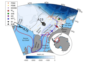
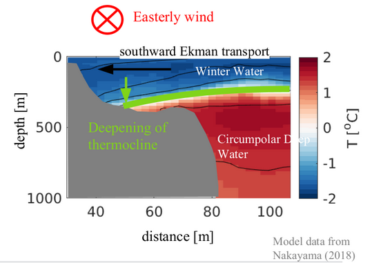
1) Eastward wind will (in the southern hemisphere) cause the surface water to move southward. (Oceanographers call this the “Ekman transport”). Water will hence pile up along the coast, along the green lines in the figure below.

Map showing winds (red arrows), Ekman transport (black arrows) and areas with coastal downwelling (green). Courtesy: N. Steiger

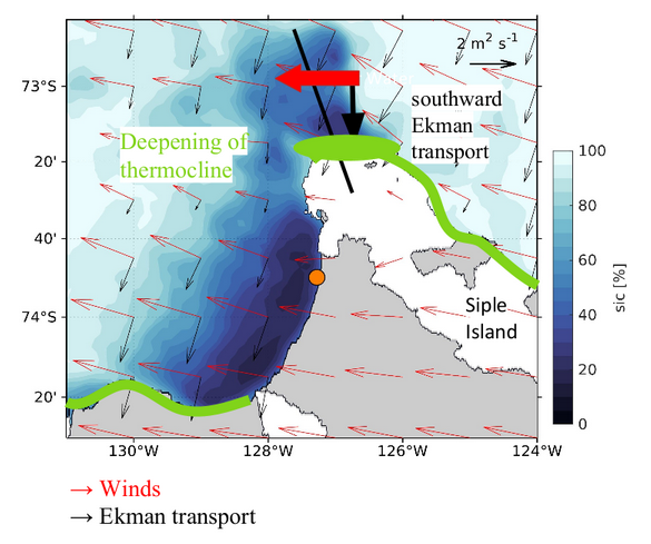
2) When surface water piles up along the coast, it will press down the warmer water below (Oceanographers call this “coastal downwelling”)

Ekman transport towards the coast will press the warm water deeper down. Courtesy: N. Steiger

3) The disturbance (i.e. the signal with depressed warm water) will travel along the coast (Oceanographers would call this a coastally trapped, internal wave. The wave is “internal” because the signal is traveling on the interface between two water masses, not on the ocean surface) and reaches the western Getz ice front 3 days after the storm! The figure below shows the observed temperature& salinity in the vicinity of the ice front, and below you see the wind and sea ice concentration. Each time the temperature at depth drops (marked by green triangles) there has been a storm just before!

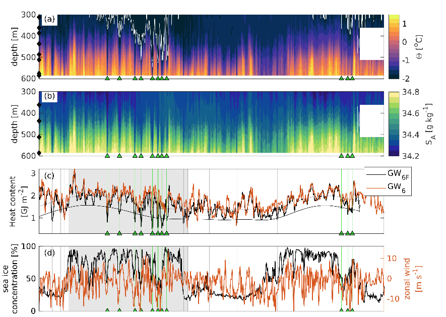
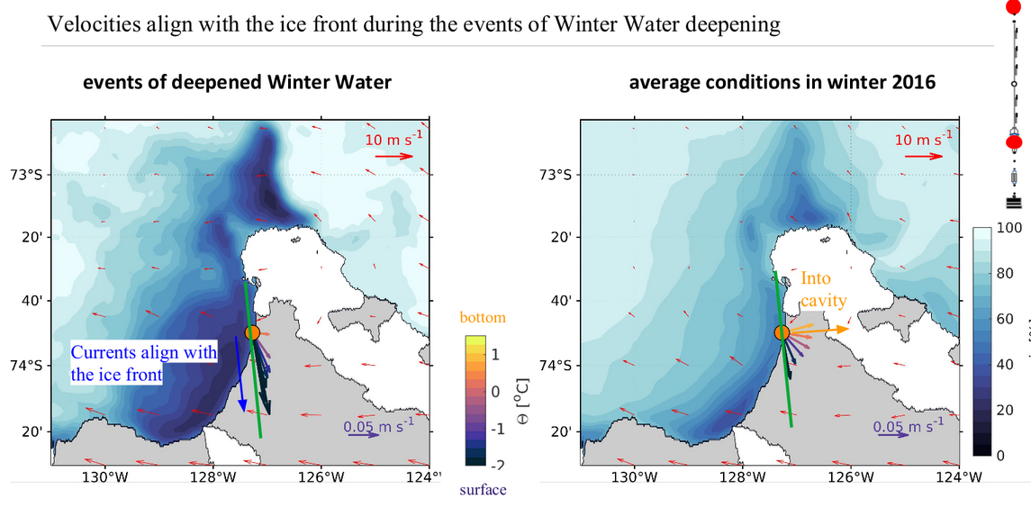
4) When the wave arrives at the ice front, two things happen. Firstly the thickness of the warm water layer is greatly reduced (see above) and, secondly, the current changes direction so that the flow at depth is aligned with the ice front rather than to enter the ice shelf cavity like it normally does.

Observed mean currents (and temperature) during a) the cold events and b) the deployment period. Courtesy: N. Steiger

During the winter of 2016, this happened at least eight times – causing a reduction of the heat transport into the cavity by about 25%!

Well done, Dr. Steiger!!!

PhD. Nadine Steiger and a proud, ex. supervisor. Photo Andreas H. Opsvik


Good news from NFR!

What a morning! Scrolling through the newly published list of funded projects from the Norwegian Research Council while sipping your breakfast tea and finding this:

is even better than learning that Sweden qualified for the quarter-finals yesterday!

… and further down on the list I found this:

where I’m also involved!

I’m super excited to lead/join these interdisciplinary projects on Norwegian/Greenlandic fjords and climate change!

Masfjorden, here we come! The Bjerknes Center will fund our multi-disciplinary fjord project!

Yesterday the Bjerknes administration announced which of the “internal projects” they are to fund during the next four years – and I was very excited and happy to learn that our multi-disciplinary fjord project (led by Mari Myksvoll) was one of them!

Together with paleo-oceanographers and biologists, we will dive deep into the basins (and the mud/sediments) of Masfjorden to study how (and why) oxygen concentrations have varied in the “recent past” (the last 400yrs or so) and how that affects the ecosystem in the fjord.

I’m really looking forward to working locally – not only “locally” as in a nearby fjord, but also “locally” as in “together with colleagues in neighboring offices and buildings”! It’s is such a great team!

Proposal-funding-celebration outside GFI earlier today with parts of the new “Fjord-team”!


Do you miss Ninja?

Well – don’t worry! Dr. Ruth Mottram, a Climate scientist at the Danish Meteorological Institute is on her way to the Greenland Ice sheet and she is bringing “Ice Man” and “Bat Girl” (likely friends of our Ninja) along! Read her cool story here! (The story “Ninja goes South” is still on Flickr.com!)

Ice Man desperately needs to get to the Arctic – read the story by Ruth Mottram here! Photo: R. Mottram.


A76 – the largest iceberg in the world (at the moment)

My lunch out in the sun ended abruptly when my husband (also in home office) casually asked if I’d heard about the new iceberg in the Weddell Sea. If my husband – an economist – has heard about an iceberg it’s likely to be big… so I shuffled the rest of my pancake into my mouth and ran in to read!

And yes, a quick google revealed that a huge chunk (4320 km2, to be precise) of the Ronne ice-shelf has broken off! A76, as it is called, is now the largest iceberg floating around Antarctica – but (according to NewScientist) it would not make it onto the top ten of historical giant icebergs.

Will A76 end its days here, in the iceberg graveyard off South Orkney Islands?

It will be exciting to see where it drifts off to – and how it will influence the circulation on the continental shelf in the southern Weddell Sea. One of its old relatives, A23, that broke off from the neighboring Filchner ice-shelf in 1986, is still (!) stranded on the continental shelf, affecting e.g. the sea-ice distribution in the region.


The southern Weddell Sea with the location of A76 (not to scale) and the old A23. Modified from Ryan et al, 2017.

Into the “grand canyon”

You might have heard on the news a few weeks ago that a large iceberg
broke off from the Brunt Ice Shelf, in the Weddell Sea. If you follow
the “Antarctic” news – and have a good memory – you might also remember
that a few years ago (2016), the UK research station Halley, that used
to be situated on what is now an iceberg, had to evacuate scientists and
personnel and  move the relatively newly built station as the crack
suddenly started propagating faster than anyone expected. Halley is the
only research station that I know about which is built on skis, so it
was “simply” pulled to a new, safe location on the other side of the
crack!

Ninja and I watching the position of the iceberg as the ship (colored line) heads into “Grand Canyon”.

Anyway – the iceberg, which got the official name A74, finally broke
off, and it has now drifted a couple of nautical miles away from the
remaining iceshelf, leaving a “canyon” between the shelf and the iceberg
that is wide enough for Polarstern to enter. The scientists studying the
ocean floor – benthic ecosystems and sediments – where very eager to get
there to sample what was until recently a sub-iceshelf (and thus very
difficult to access) system.

Ice berg or ice shelf?

We were all excited about circumnavigating A74, and to enter what we
quickly named the “Grand Canyon” – and most of us have followed the
motion of the iceberg on the satellite pictures that we receive every so
often. Is the “canyon” widening or shrinking? Are there smaller icebergs
blocking the passage? Can we get through? The sun, which we haven’t seen
much of during this expedition, obviously were just as excited as we
were, because it decided to join us for most of the day in the canyon
offering a spectacular view of the glittering bluish ice walls around
us!

We got to do three stations in the “canyon” – with intensive sampling of
both the water column and the bottom sediments. The AWI OFOBS team sent
down their camera system, and we could watch the ocean floor beneath us
live on their screens. To me, a non-biologist who are just about able to
distinguish a fish from a sponge it looked mostly like the open ocean
stations we’ve occupied earlier, but to the experts, things were
apparently different. Hopefully they get to repeat the station in the
years to come, to study how the community evolves now that it no-longer
has an ice shelf roof over its heads.

The OFOBS screens showing live video from the ocean floor beneath us were drawing a larger than usual audience

The CTD-profiles we made in the “canyon” all looked more or less the
same – a straight line from surface to bottom (i.e. close to constant
salinity and temperature). Supercooled Ice shelf water (a lighter
version than what we find in the Filchner Trough) was flowing out of the
Brunt ice shelf cavity, and the formation of buoyant  ice crystals at
depth  were clearly visible in the images from the OFOBS team! The ice
crystals had also clearly aggregated on the “geo-bio-chemical-lander*”
line, which were deployed for about 8 hours at one of the stations. When
the lander was recovered, there was a 1 cm thick layer of ice on the
line!

*a big thing full of instruments (for bio-geo-chemical process studies)
that looks like something that would land on the moon.

It is easy to write home about cute seals and beautiful icebergs, but much more demanding to tell about things that are not as nice #InternationalWomensDay

It is easy to write home about cute seals and beautiful icebergs – but
much more demanding to tell about things that are not as nice.
In a way,  every research expedition is a social experiment – you find
yourself isolated on a ship with lots of people you never met before,
you live, eat and work with them and there is no way to escape.  I have
always loved being at sea, to enter this small bubble where everything
is here and now and the world outside is far away. But just like in any
reality show where they close people up together, there will inevitably
be conflicts (and every now and then a romance), there will be good guys
– and bad guys. Unfortunately, I was put on a shift together with one of
the latter. He obviously considered himself superior to me in all
possible ways – in addition to being generally arrogant, he made it
perfectly clear that what I did was no good, that I was not to be
included in discussions (neither scientifical nor social) and that, as
he put it, it was just stressful to have me around. I tried talking to
him about it – without success – and at some point, I just walked away
from it all, crying.

Later, I had a good talk with my group leader about it – many thanks to
him (and others) for support – I’m not on that shift anymore, and I’ve
decided it will do me no good to talk to the person in question again
right now, so I just stay away.

I am still disappointed with my own reaction. I know a male colleague
likely would not have reacted that way – but I also know that a male
colleague likely would not have been treated that way to start with. I
wrote about this on Twitter and was contacted by two younger women who
have had similar experiences, with the same person. Reading those
e-mails made me so angry I had to go down to the gym for an hour to run
it off.

Today is the international Women’s day. More than once in the past have
my daughters returned from school on this day, saying “Congratulations
on Women’s Day” – and more than once have I tried to explain that they
should not be congratulating, that it is actually depressing that still
in 2021, we need this day. That still in 2021 men and women are not
being treated equally.

Pancakes for breakfast on Polarstern – and pancake ice outside!

Breakfast on Polarstern is served between 07:30 and 08:30, and my usual
order to Maya behind the counter is “Zwei Pfannkuchen, bitte” – two
pancakes, please. But today there were pancakes not only on my plate in
the canteen –  the ship is surrounded by them! Rounded, small ice floes
with slightly elevated edges. My favorite type of ice!

It’s been quite cold the last couple of days and ice formation has
really kicked off. Autumn and winter is approaching rapidly! When I’ve
been up at the bridge to do sea ice observations in the mornings*, I’ve
started to use terms like “Nilas” and “fingerrafting” in addition to
“first and second year ridged floes” which is what we have had around us
before. When ice is formed on the ocean during calm (little wind)
conditions, the ice crystal initially makes a grey  ice “carpet”
(Nilas), that bends nicely over waves and that will break in “fingers”
that slide alternatively under and above fingers from the neighboring
“carpet” when the ice converges.

Finger rafted Nilas bending over the waves in the wake of the ship.

In windy conditions, the ice crystals will be forming not only at the
surface, but also in the upper (10-20m) of the water column and the
buoyant ice platelets rise to the surface and form what’s called grease
ice (it looks really greasy). Because of the motion in the water
initiated by the wind (Langmuir cells), the grease ice will typically
form streaks in the water surface, aligned with the wind. If freezing
continues, the grease ice will turn into small floes, that continuously
bump into the neighboring floes as they are moved around by wind and
waves, and the floes therefor end up having rounded shapes and elevated
edges – pancakes! With time, the pancakes grow, as small pancakes grow
together or raft on top of each other.

White pancake ice

The pancakes we have around us now was formed further north – and the
biologists on board are super excited about these pancakes. Pancake ice
is generally white or grey – but our pancakes are turning more and more
yellow! Some form of biology is thriving on (or under?) the pancakes –
and since the bio-geo-chemists have not seen this before they are all
very keen to get out on the ice to sample!

Yellow (consolidated) pancakes.

Personally, I prefer white pancakes on the ocean and yellow pancakes
(with jam) on my plate!

*we do sea ice observations every hour when there is daylight, and seven
o’clock is my slot