…on the radio!
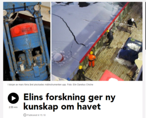
Those of you who understand Swedish (or is it “Svorsk”?) can listen to me trying to explain what we do in Antarctica to a Swedish journalist here: Radio Halland

…on the radio!
Those of you who understand Swedish (or is it “Svorsk”?) can listen to me trying to explain what we do in Antarctica to a Swedish journalist here: Radio Halland
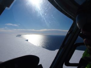
I’m still in the Bjørnafjord doing one last section before we head back to Bergen – but I just had a report from Svein Østerhus and Polarstern. They are now just north of the front of the Ronne Ice shelf in the Weddell Sea.
Scientist from British Antarctic Survey are onboard with “Boaty McBoatface” – an unmanned, autonomous (i.e. not attached to a cable) submarine with sensors for just about everything onboard – that they plan to send on a mission beneath the Ronne ice shelf! Truly exciting!!! I’d love to be there…
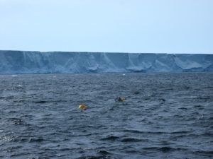
While being in the vicinity of the ice shelf front, Svein will deploy a couple of temperature recording LoTUS bouys (see previous post) within the ice shelf front polynya* for me. These will remain five years at the bottom before surfacing… so be patient!
*a polynya is an area within otherwise ice covered water. Tidal currents and wind typically keep the area just in front of the ice shelf front ice free during summer, and often also during winter.
Amongst the facebook birthday wishes in my inbox I also found this perculiar Message:
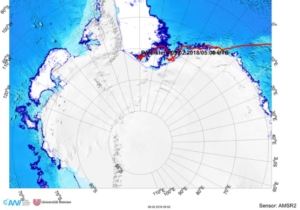
Transmit Time: 2018-02-02T13:41:59Z UTC
Iridium Latitude: -77.0799
Iridium Longitude: -33.8234
Data: 2c31362c54454d50313030302c323031372d30312d30312030303a30303a30362c36302c393534302c333630302c2d312e3837312c333233392c332c3630382e33342c3630352e39312c31312e30322c76322e362e382c31363031383b…
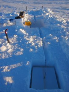
which means that at least one of the LoTUS buoys that I deployed last year did what it was told and surfaced today!
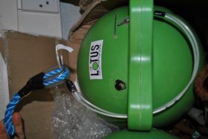
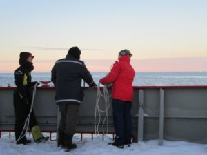
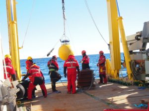
LoTUS stands for “Long Term Underwater Sensing” and it is a bottomlander that you more or less through over the side of the ship. It sinks to the bottom, where it measures the tempearture until it is programmed to let og of its weight and come to the surface. Once at the surface, it transmits the data back to us in the office via satellite. Very nice!
The number in the Message above are as in-understandable to me as they are to you – but hopefully the instrument devellopers from KTH will be able to transform them into understandable data… a one year long temperature record from a location just north of the Filchner Ice Shelf front in the Weddell Sea! There was one more buoy that was programmed to come up today and which didn’t yet report home – so keep your finger’s crossed!
A collegaue of mine, Svein Østerhus, is currently onboard Polarstern in the Weddell Sea, and he will deploy more of these buoys for me later during the cruise!
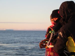
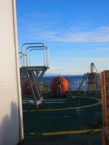
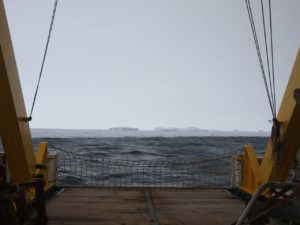
Below are a few Pictures from the LoTUS buoy deployment last year:
 Guest blog by Karen Assmann
After our outing on to the eastern Getz Ice Shelf, the weather got a bit worse again we continued our way east with more moorings being recovered and deployed and three ocean gliders going in the water. These small autonomous underwater vehicles will spend the next year going in and out of the Dotson Ice Shelf cavity, if everything goes to plan. Getting ocean observations in the ice shelf cavities, rather than along their edges like we do with ships and moorings, is difficult. The few observations that exist come from drilling holes through several hundred meters of ice and deploying instruments through them or from sending bigger unmanned submarines into them. So sending ocean gliders that normally profile the surface ocean into the cavity under the ice shelf is rather daring. If the project by the University of Washington and Columbia University succeeds, it will mean that we will learn a huge amount about what happens in the ocean under the shelves, but the risk that the ocean gliders do not make it back out is high.
At this point the weather turned good again and we dashed east across the bay to start on the next lot of helicopter work. This was to include the replacement of an automated weather station (AWS), and two days of radar and magnetics surveys and ApRES deployments on Thwaites Glacier and Dotson Ice Shelf. We were crossing fingers for 3 days of good weather. The AWS replacement on the first day ended rather abruptly, when the old weather station couldn’t be found and the responsible scientist decided not to replace it with a new one. Preparations for the second day of air operations came to an abrupt halt when a leak in the hydraulic system of one of the helicopters was found. Despite best efforts and extensive spares kits the leak couldn’t be fixed and this spelled the end of any work that needed a helicopter. Two working helicopters are needed for safe operations as an emergency backup, so the fact that one of them was no longer safe to fly meant the other couldn’t fly either. After a brief pause to re-group, on we went with the ocean work on the schedule while considering what could be done with the time that has suddenly become available.
Guest blog by Karen Assmann
After we finished our mooring marathon at the western Getz ice shelf we started to make our way east towards the Amundsen polynya. One stop on the way was the last UIB mooring that was placed in one of the smaller openings of the ice shelf. The area where the mooring was located had been covered in fast ice and heavy sea ice since we started monitoring sea ice conditions at the start of the cruise. When we got there the mooring position was located in open water about 100 meters from sea ice that was tightly packed by strong winds. After a bit of deliberation we decided not to release and recover the mooring, because we were worried that the strong winds and surface currents were going to carry it into the sea ice. We did however talk to the acoustic release and worked out that the mooring was still where we had left it two years ago.
Then we turned further eastward to make use of a weather window that would allow us to complete some of the helicopter work that was on the schedule. As well as a joint KOPRI/University of Bergen/University of Gothenburg effort to deploy autonomous phase-sensitive radars ApRES to measure ice shelf basal melt rates, there was also a group from the University of Texas who had installed radar to measure the ice sheet structure and magnetics equipment to find out about the type of ground under the ice on one of the helicopters. After being windy, snowy and cloudy for a few days the weather turned sunny, clear and calm on 22 January that also happened to be my birthday. After a few delays we loaded our equipment into one of our helicopters, hopped in and away we went over the cliff of the ice shelf edge onto the white expanse of the eastern Getz ice shelf. I have been involved in research around ice shelves for 20 years and two years ago I finally got to stand on one. This time was just as exciting even though at the surface and ice shelf is just very flat and white and big.
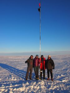
We spent a bit of time setting up our first ApRES site, while the helicopter shuttled out more equipment and fuel drums for the other helicopter to refuel while doing its radar and magnetics surveys. Then we loaded everything into the helicopter and moved to the second site where the setup went much faster, partly because we now had the pilot to help as well, partly because we had now worked out how to do things efficiently. After a photo session we took the scenic route back to the ship.
In some ways it was lucky that Johan only realized quite how full the schedule was going to be at the western side of the Getz ice shelf two days before the cruise. Otherwise he might not have agreed to come on the cruise. The change of schedule had moved this work to the start of the second half of the cruise and there were only two stations before we started our first mooring recovery at 22.00 on 18 January.
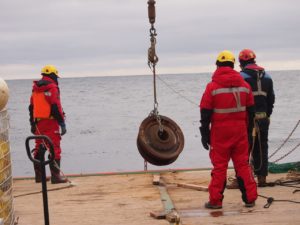
After a few pings from the deck unit the release on the first mooring woke up and we got the okay from the bridge to release the mooring. Shortly afterwards we spotted the orange buoys at the surface and the ship inched up to them to catch the top float with grappling hooks and to start pulling the rope, floats and instruments onto the ship over the stern. The whole recovery took about an hour and by about 07.00 in the morning we had recovered two more moorings, the last rather close to the ice shelf edge. Mooring two didn’t tell us that it had released and just popped up to the surface. The top instrument on the third had been pushed to the next one below by an iceberg, but both were fine.
To get the new moorings into water we had to download the data from some of the instruments, change their batteries and give them a service as quickly as possible to not keep the ship waiting too long. Luckily we had help from the glider team and just after lunchtime we were ready to deploy the first of our new moorings. These first two deployments took us to dinner. The transit to the other side of the ice shelf gave us the opportunity to catch a few hours sleep before the last recovery and deployment. Those came and went without any problems as well and both us, and the deck crew were getting so efficient at the whole process that the time we were given on the schedule for each recovery and deployment was reduced from four to two hours. By the time it got to breakfast on 20 January we were finished, 34 hours after starting with all four moorings that we deployed in the area two years ago successfully recovered and three new ones in the water to take over their work.
Guest blog by Karen Assmann
About a day from the sea ice edge a meeting was called. The ship had turned around towards New Zealand, because a crewmember had become seriously ill and the ship’s doctor together with medical advisors from Korea had decided that he needed treatment in a hospital. At that point we were 7 days from New Zealand, 7 days from Patagonia and 5 ½ days from McMurdo Station in the Ross Sea, and thus truly in the middle of nowhere.
All preparations for Amundsen Sea science stopped and as the condition of the sick crewmember stabilized, contingency plans for the fact that we were losing 14 days of our time to do field work in the Amundsen Sea started to be made. A day before we reached Lyttelton, SangHoon Lee, the cruise leader of the cruise, got the news from KOPRI that we were only getting two extra days, less than we had hoped for, but understandable, since there are two more cruises after us before the end of the season.
It hadn’t really been in the plans, but the stop in Lyttelton became hotly anticipated. Shopping lists (more bread supplies) and plans for the day were made. Since all preparation for science had been stopped, life on board slowed down.
Despite the fact that the condition of the sick crewmember had stabilized a little bit, it was still a relief to see him safely delivered into an ambulance at the quayside in Lyttelton. The rest of us spent a rainy, but very enjoyable day wandering between various cafes, restaurants and shops recharging for the busy second part of the cruise.
A new plan appeared that still included a large amount of the work in the previous, much longer one – impressive work by SangHoon and TaeWan! The order of things had changed and our moorings at the western side of the Getz Ice Shelf were now top of the list. After establishing that we still had time to be able to deploy the same number of moorings as before, I started to make up new plans with the instruments that we were going to recover from the sites at western Getz. Slowly, but surely preparations started up again and have been gaining momentum.
Yesterday we finally got to the sea ice edge and tomorrow our mooring work will start with a few very busy days Ahead.
Guest blog by Karen Assman
After leaving Gothenburg on 12 December in the snow, I spent a warm day exploring and eating my way through Singapore on the way to Christchurch, New Zealand and then a few days getting over the jetlag in New Zealand summer. On 17 December it was time to return to Christchurch and meet up with Johan, the technician who is helping me with the moorings on the cruise. We spent the next day shopping for a few bits of equipment that had appeared on the list after the container had left for New Zealand in early October. If anybody should require a chandlery or hardware store in Christchurch I can probably point them into the right direction. On 19 December we went to the port in Lyttelton and said hello to Araon who had come into port. Almost all our equipment was on the quayside next to the ship – apart from the mooring anchors that should have been delivered from Wellington that day. The agent assured us that they were probably on their way and we went off to buy last minute supplies like snacks and flour for the bread maker etc.
Loading the equipment that was on the quayside and finding space for it on board went very smoothly the next day and we were finished by lunchtime. But still no mooring anchors. A phone call to the very helpful technician at the New Zealand Institute for Water and Atmospheric Research (NIWA) who had organized the anchor weights for us told us that the weights were still in Wellington. She managed to impress on the freight company that the anchor weights needed to be with us in Lyttelton the next day and things started to finally move on the tracker app.
We were scheduled to leave on 21 December at 14.00 and after delivering the rental car back to the airport in the morning, Johan and I took a taxi to Araon. At 11.00 the tracker app told me that the anchor weights had made it to the Christchurch depot of the freight company. A phone call to check when they were being delivered turned out be rather essential after it turned out they weren’t to be delivered until the next day. After the phone call they were practically on their way and did make it just in time. The first mooring line for the ship was let go as soon as the last weight touched the deck. And we were on our way!
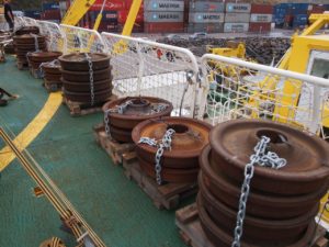
So why were we so anxious about 5 tons of old train wheels? The driver delivering the weights did wonder, as might you. Are you going to sink them? Essentially that is what we are going to do. The strings of moored instruments that we are going to deploy have buoys to hold them upright in the water column and to give us data at different depths and so they need something heavy at the bottom to anchor them to the same spot, until we come back two years or so later to release them.
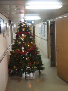
The Amundsen Sea is a long way from anywhere – part of the reason why it remained unexplored until relatively recently. Our first mooring was scheduled for day 16 of the cruise and we settled into life on board, doing bits of preparation, other work, going to the gym, meeting our shipmates for the cruise and getting the on-board bakery, i.e., the bread maker going. A Christmas tree appeared in the hallway and we had a party on Christmas Eve to mark the occasion. Sea and weather were kind to us, so the sailing was smooth and it felt more like a cruise to the sub-tropics. This was partly due to the fact that the ship was going east to the Udintsev Fracture Zone to retrieve three moorings that had been deployed there on the last cuise and to do a hydrographic survey. Fracture zones are gaps in the sub-sea ridges that run across the abyssal planes of the world oceans. The Udintsev Fracture Zone steers the Antarctic Circumpolar Current that encircles the Antarctic continent southward and is thought to be one of the reasons why warmer water reaches the ice shelves in the Amundsen and Bellingshausen Seas. After recovering two of three moorings and shaking out a few teething problems in the sampling equipment on board, we started to head south towards the Amundsen Sea and as it started to snow things were looking distinctly more polar.
Karen’s texts got stuck somewhere between the ship and Bergen…. but now they are here and I’ll share her reports with you! First some background…
Why are we going to the Amundsen Sea, who is going on the cruise and where is the Amundsen Sea anyway?
For a long time nobody went to the Amundsen Sea. James Cook turned around at 71° 10’ S in 1774 faced with thick multi-year sea ice and apart from one more attempt by the Belgica in the early 1900s, no ship went there until 1994. That cruise discovered that the bottom layer of water on the continental shelf was filled with warm (1-2 C) and salty water and this explained the high melt rates that glaciologists were seeing under the floating ice shelves that fringe the area. Interest really rose when the glaciologists realized that the area had the highest thinning rates on the Antarctic Ice Sheet. Since the atmosphere in Antarctica is generally too cold to cause much melting at the surface of the ice sheet, the warm ocean layer and the high melt rates in the ice shelf cavities was identified as the culprit. So for the last 15 years there have been regular scientific cruises to the Amundsen Sea to find out what controls the flow of the warm water and how and why it may have changed to cause the observed thinning of the ice shelves.
Our cruise is part of this effort. We are on the South Korean Research Ice Breaker Araon that is owned by the Korea Polar Research Institute KOPRI. Two years ago we went to the Amundsen Sea to Araon to deploy an array of moored instruments to measure the flow, thickness and temperature of the warm water layer. One of these sites has had oceanographic instruments for 8 years, the others have never had any instruments before. Hopefully all of our so-called moorings will have measured temperature, salinity, oxygen and current velocities over the past two years and will come back in one piece when we release them.
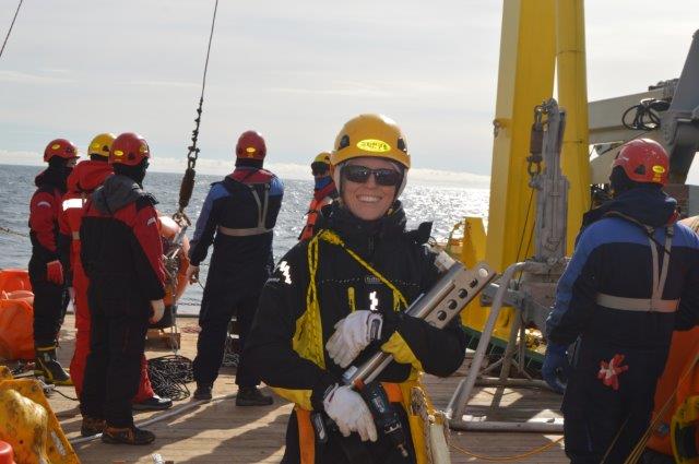
My name is Karen and I work as a researcher at the Department of Marine Sciences at the University of Gothenburg. I have done research in the Antarctic seas and how they interact with the sea ice and ice shelves since my PhD. Then I was mainly using numerical models, now I am mainly working with observations. I was on the Araon cruise two years ago when we put the moorings into the water that we are now recovering. I have started crossing my fingers that they all come back and am really excited to start looking at the data. On board Araon I also run the bread maker a.k.a. the on-board bakery – Korean breakfast isn’t for everybody!
Johan Rolandsson works as a marine technician with MMT (Marine Measurement Technology) in Gothenburg. He went on the Araon cruise in 2014 and will help me with the mooring recoveries and deployments.
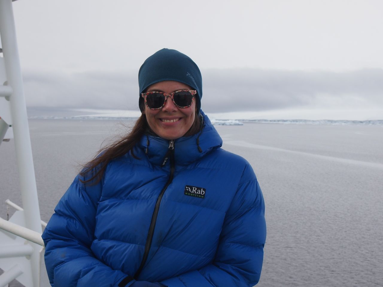
Karen on the last Araon cruise to the Amundsen Sea.
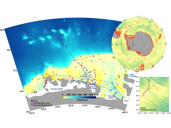
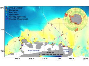
The initial cruise track and stations (courtesy of TaeWan Kim).
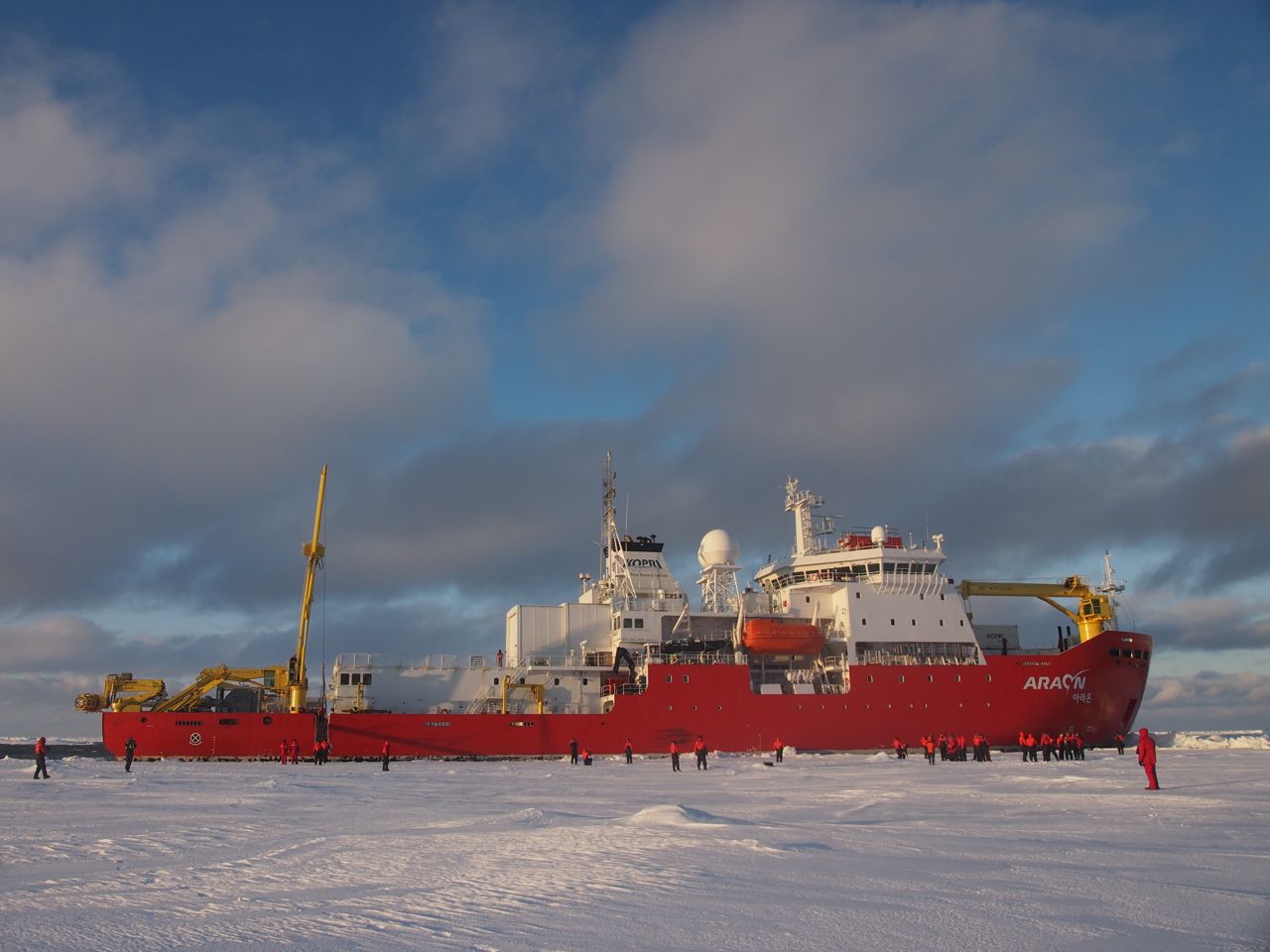
The South Korean research ice breaker Araon in her natural element on the 2015/16 cruise.
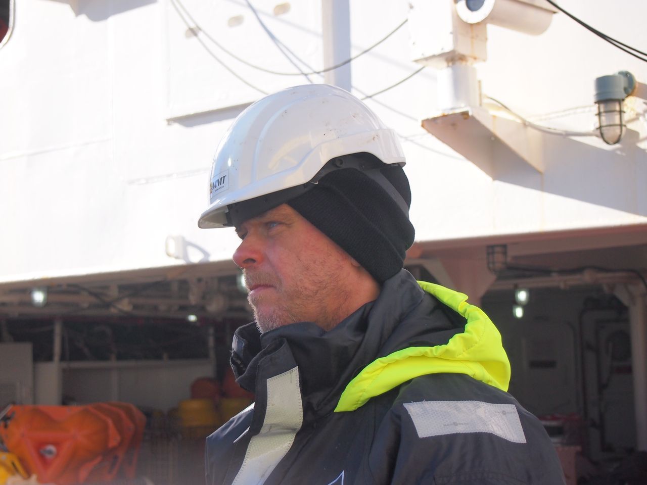
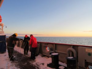
Johan waiting for a mooring to appear on deck.
I’m spending the austral summer at home in Bergen for a change – but luckily I’ve got People Down South helping me out! Karen Assmann & Johan Rolandsson from the University of Gothenburg is onboard the Korean Icebreaker Araon in the Amundsen Sea, and these days she’s busy recovering moorings with oceanographic instrumentation that we deployed during a cruise in 2016. During the weekend (while I was out skiing) I received message after message: one more mooring on board!
For now three of my moorings are recovered, meaning two years of data on the flow of water towards and away from the western most front of Getz ice shelf. Until now there were no data at all from this region during Winter!
There is still one more mooring to go – but there is a lot of sea ice around, so not sure they’ll be able to pick it up this time around. Finger’s crossed!
You can see where Araon is if you click here!
I’ll let you know what happens and hopefully get Karen to send some photos – but for now, I just want to say “Thank you Karen and Johan, well done – and thank you Hoon and KOPRI for letting us join your cruise!”