The influence of the ocean on Fimbulisen

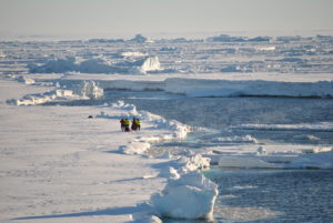
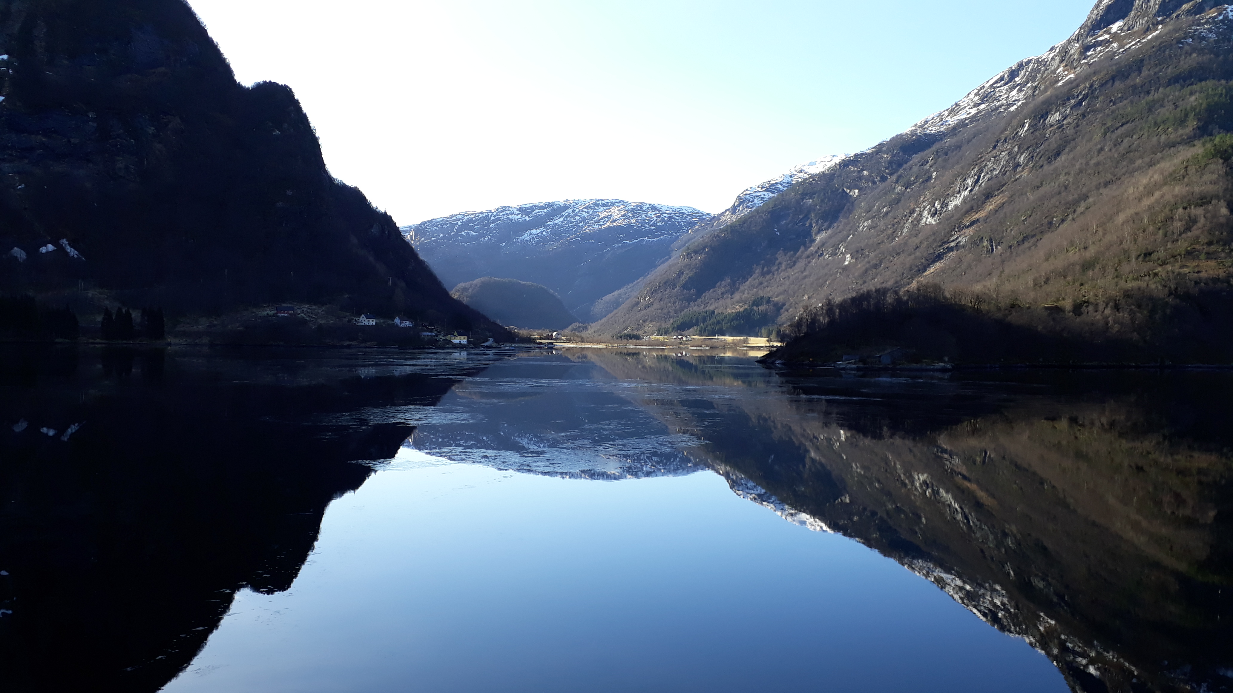
In the last blog post, Elin wrote that I called her with bad news from Dronning Maud Land, because the ice didn’t allow us to deploy the mooring. But what was actually our aim with that mooring? What did we want to learn? For that I need to tell you about the Southern Ocean and ice shelf ocean interaction…

The Southern Ocean is very important for the global system for different reasons:

  • Cold temperatures and high salinities close to the Antarctic coast form very dense water masses. They sink down to the bottom of the ocean and drive the whole global ocean circulation.
  • The ocean can melt ice shelves – the floating extensions of the ice sheet. Consequently, more of the Antarctic Ice Sheet flows into the ocean and causes sea level rise.

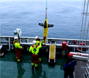
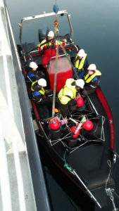
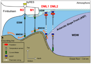
Regarding the ice shelves, they are mainly melting because “warm” water reaches the ice. “Warm” in this sense is not really warm… It only means warmer than the freezing point, which can go Down below -1.9oC in salt water and under higher pressure at depth. It is very difficult to measure temperatures and currents under an ice shelf. But 10 years ago, one of our oceanographers on board, Tore Hattermann from NPI, went to the ice shelf Fimbulisen here in Dronning Maud Land to drill holes in the ice shelf and install moorings underneath. Since then, those mooring have been measuring temperature, salinity, oxygen and the current speed underneath the ice, where we otherwise can’t measure anything Those are really impressive data!

Sketch of Fimbulisen with the moorings installed under the ice shelf (M1 & M2) and the moorings we wanted to install in front if the ice shelf during this cruise (DML1 & DML2; Hattermann et al., 2012).

So what did Tore find out?
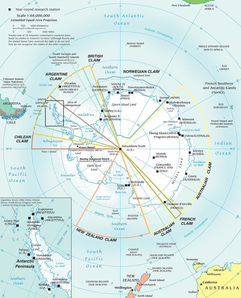
There are three different ways how warm water can reach an ice shelf (Hattermann et al., 2012):

  • Water that is a the freezing point at the surface cannot melt ice at the surface. But ones it sinks further down, the freezing point decreases because of the higher pressure, so the water is warmer than the local freezing point and can actually melt the ice.
  • Warm Deep Water (T < 0.6oC), which is off the continental shelf break and in greater depths can spill over the continental shelf break in short pulses. It flows then into the ice shelf cavity on the bottom as Modified Warm Deep Water.
  • In summer, the surface heats up by the sun. The Winds can then press the surface heated water Down to Depths where it can enter the ice shelf cavity.

However, the heat entering the cavity through those processes is relatively small in the case of Fimbulisen and the melt rate beneath  the ice shelf is low. But what does it have to do with our cruise?
We want to know, how the water masses in front of the ice shelf, at the continental shelf break change with time. Therefore we wanted to install more moorings that could measure the depth of the Warm Deep Water etc. Maybe the winds change with time and consequently also the currents? Also changes in the sea ice can change the density of the water and cause a change in water masses.

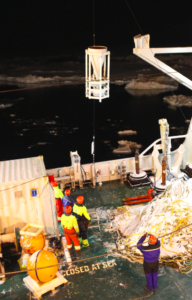
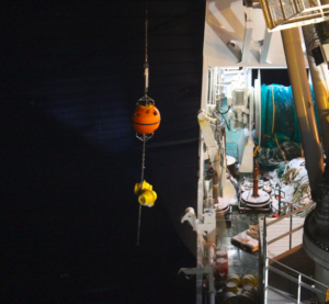
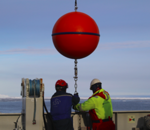
It would have been very interesting to study those processes in an area, where so good data from the ice shelf cavity and ice shelf melt exist. We were therefore quite sad, that we couldn’t reach far enough south due to the sea ice restrictions. Luckily, we managed to install two other mooring that the oceanographers from NPI brought, although we had to place them further north than intended. We’ll find out in two years if the data are interesting! And keep the fingers crossed that the instruments won’t get overrun by icebergs or break for other reasons!

First mooring from NPI that we installed during night west of Astrid Ridge. Here, the sediment trap as part of the mooring is being lowered into the water.
The last instruments of mooring 1 are lowered over board with a big crane.
Lowering a flotation element of mooring 2 into the water. In the background sea ice and icebergs.
Together with Kristen, I am attaching one of the temperature sensors on the mooring that will go in the water.


Changing plans…

Sea ice – beatuful to look at, but difficult to make plans With…

My phone rang twice yesterday – the first time it was Anna Wåhlin, who had just sat her feet on land again in Punta Arenas, Chile after two months in the Amundsen Sea With Ran.
The second time it was a local, Bergen number and I was very surprised to hear Nadine’s voice on the line! It still amazes me, that (when things work) you can talk to someone on a ship in Antarctica and it sounds as if they are in the room next door…
She had bad news, there were too much ice, the captain couldn’t go nearly as far south as we had hoped for to deploy Our moorings and we have to move them further north to deeper water. 1500m instead of 800m. Where should we add the extra line? Should we rearrange the instruments? We discussed a bit and agreed on a solution.

When I woke up this morning there were five missed calls from the same Bergen number – and there was soon a new call from Nadine.
– More bad news. The captain couldn’t make it even to 1500m, they were now about to deploy the NPI mooring at 2000 m. What should we do with ours? No point in going deeper, we don’t have more lines to add and many of the instruments can’t be deployed that deep. Deploy it on Maud Rise? Move instruments over to the NPI mooring and bring the rest home? Bring them all home? Not an easy decision!

A history lesson on Dronning Maud Land

The first person who set his foot on Dronning Maud Land was a Scottsman William Bruce. After that, the Norwegian ship owner Lars Christensen financed 9 expeditions for whaling and sealing with the ships “Odd”, “Norvegia” and “Troshavn”, as well as aircrafts to map the area. The first expedition was under Hjalmar Riiser-Larsen in 1929-30 when the name Dronning Maud Land was first applied. To claim the area as norwegian territory, a norwegian flag was thrown out of an airplane at the western boundary. In 1938-39, the Germans started an expedition led by Alfred Ritscher with the ship “Schwabenland” and two aircrafts that they used to fly over the territory seven times within 17 days, They photographed an area of 350 000 km² and dropped down several Nazi-flags. They wanted to claim the area as theirs.
Luckily, the norwegian Adolf Hoel came for a visit to Berlin, where he found out that his friend had left to an Antarctic expedition. Adding two and two together, he guessed what the Germans planned and notified the Norwegian government. On 14 January 1939 – five days prior German arrival–, king Håkon VII officially annexed Dronning Maud Land as Norwegian territory.

Beautiful phytoplankton – the basis of the marine food web

On the way to our intensive study area in Dronning Maud Land, the work package leaders on RV Kronprins Haakon constantly have to keep the cruise plan updated with the time schedule and with sea ice conditions, weather and whatever interesting is coming up on the way.

In one location, the observers on board spotted more than 100 whales, compared to about 5 on other days. The whales are there for one reason: food! And the food chain starts all the way down with primary producers that are the food for krill. The Antarctic krill has an estimated biomass of around 389 000 000 tonnes, which is more than the global population of humans! More than 50% of this mass fuels the ecosystem: the whales, seals, penguins, squid and fish.

Primary production in the Southern Ocean is generally low despite high nutrient concentrations. This is due to low iron concentrations. It increases close to islands, coasts, sea ice edge and icebergs. In Dronning Maud Land, many processes that increase primary production come together and green sea ice filaments can even be seen on satellite images.


Measuring the ocean with autonomous submarines

On Tuesday, we sent two autonomous submarine on their missions in the water (read about their big sister, the Swedish AUV of Anna Wåhlin here: Rand under Thwaites) ! They are seagliders, autonomous underwater vehicles that measure physical ocean properties automatically. Instead of propellers, they use buoyancy and wings to dive down to about 1000 m depths and up again. This means they move up and down in a zick-zack pattern. Once at the surface, they can communicate via satellite to a remote pilot to send the data and the location. The pilot can then change the route or give new commands. A seaglider can dive over several months without running out of battery, and it measures with very high precision. It is impressive, that even though we are in Antarctica, the pilots can control it from the Geophysical Institute in Bergen and even get data immediately each time the glider comes to the surface!

Glider deployment from RV Kronprins Haakon in Dronning Maud Land. Both sea gliders we are are provided from Ilker Fer’s Norglider team at GFI, UiB in Bergen.

Those gliders will now be diving in the water for about 3 weeks. Until then, they have moved further south and we can pick them up again. Hopefully, everything goes well and they don’t hit the sea ice! We already had to change their routes, because of an increased sea ice cover in the areas where we wanted to go. One of them now dives through an area with very high primary production, where we could find a lot of biological activity!

DIY drifters!

Drifters on their way to be deployed

While Nadine is wathing icebergs drift by in the Southern Ocean, I brought the students in GEOF232 back to Masfjorden, a fjord just North of Bergen.  No icebergs to be seen there (luckily), and the only thing we saw drift by was Our own DIY drifters that we had deployed in the fjord!

A drifter is simply an Object that drifts With the Ocean currents and then on a regular basis reports its position back. Now, you can pay a lot and buy a fancy drifter… or you can build Your own (almost as fancy). That’s what Our handy technician Helge Bryhni did! All you need is some paint trays, a bucket, flotation, some rope and chain – and one of these devices that you are supposed to put on your (expensive) car so that you can find it again if it gets stolen. To be on the safe side, Helge opted for a radar reflector and a water proof container.

[vimeo 322769334 w=640 h=564]

Video by Algot Peterson, UiB

The students got to decide where and how to deploy our four drifters – spread out or together? in pairs with different depths*? near a river outlet? on rising tides or sinking tides? – and once they were in the water they could sit back and follow the drift on their mobile phone!

*by adjusting the length of the rope we could Place the bulky plastic part of the drifter on the Depth we wanted, and the drifter would then follow (and show us) the water motion at that Depth.


The daily life on RV Kronprins Haakon during the transit

Finally, we have reached our study area in Dronning Maud Land. Since we left Punta Arenas 10 days ago, we have been sailing non-stop through the Southern Ocean. You may wonder what we have been doing the whole day on board?

First of all, our instruments and gears were piled up in huge containers and had to be unloaded. Labs had to be prepared and packed into plastic to avoid contamination, bottles had to be sorted and all equipment had to be stored securely to not fly around ones we hit high waves. The group leaders used the transit time to plan our tracks in more detail, decide where to take samples and where to do measurements. Some of us already started taking measurements during the transit!

Otherwise the days are quite similar to home when we work on our computers, just that once in a while someone shouts: Iceberg! Whale! Or, watch that beautiful petrel outside! Of course, we also have to take time to clean our own workspace and do the laundry.

Scientists working hard during the transit on Kronprins Haakon. Photo: Anne Helene Tandberg, UiB

Before we went on board, most people didn’t know each other, and now we have to share the cabin with another person. You better hope for someone who is not snoring! However, we already made new friends and spend some time with social activities. On Fridays it’s quiz-night, on Saturdays we play twister, every evening after dinner we do HIIT on the Helideck and we watch movies together, play table tennis, basketball etc…. The work at the stations will work much better if we know each other well!

Workout on the Helideck. The waves make the training extra difficult. Photo: John Olav Vinje
Quiz-evening with all scientists and crew-members! Photo: John Olav Vinje

Now, we have finally deployed a Seaglider (Autonomous Underwater Vehicle) and took the first CTD (Conductivity-temperature-depth) section, which was our first station. You will soon hear more about that and other work on board!

BTW, there is also more about our adventure on the UiB webpage!

International women day

Back to RV Kronprins Haakon, we celebrate the international women today! While Elin is active in Bergen at Women in Science 14.15 @ Realfagsbygget and Anna gets excellent data from AUV Ran under the Thwaites Ice Shelf, we collected all women for a group picture on the Helideck! About 40% of the scientists on board are women, plus 3 women from the crew!

All women on the Helideck on RV Kronprins Haakon for the international women day.
Photo: Rudi Caeyers, UiT

Ran under Thwaites II!

The new Swedish AUV (autonomous underwater vehicle) heroine Ran has returned from her second mission beneath Thwaites ice shelf! Just in time for the international women’s day tomorrow!

An AUV is sent down in the water with a pre-programmed mission, e.g. “dive down to 500 m depth, swim 2 km to the east while measuring salinity and temperature and then come back here so that I can pick you up”, while a “ROV” (Remotedly operated vehicule) is connected to and steered from the mother ship via cables.

The name Ran is borrowed from Nordic mythology, where she is the goddess of the deep sea. According to the legend (and wikipedia), Ran catches seamen in big nets and then keeps them with her at the bottom of the sea. Luckily Ran escaped both the nets and the sea ice that was closing up around her pick up spot…  and made it safely back to the mother ship were Anna Wåhlin and the rest of the AUV-team was waiting. I bet they were nervous!

On her second trip, Ran ventured three kilometers in under Thwaites, and brought back information on the sub-ice shelf hydrography and currents but also water samples that will be analyzed back in the laboratory.

Ran and I have one thing in common – neither she nor I would be where we are today without Anna’s support and stubborness. I’m so happy Your “baby” is successfull, Anna. You’ve worked so hard for this to happen! Congratulations!

You can read more about Ran and the expeditions (in Swedish) here!


Ran in the sea ice (Photo: Gothenburg University)
The Swedish AOV-team. Anna Wåhlin is to the left in the first row. Photo: Gothenburg University