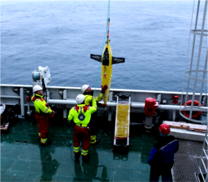
On Tuesday, we sent two autonomous submarine on their missions in the water (read about their big sister, the Swedish AUV of Anna Wåhlin here: Rand under Thwaites) ! They are seagliders, autonomous underwater vehicles that measure physical ocean properties automatically. Instead of propellers, they use buoyancy and wings to dive down to about 1000 m depths and up again. This means they move up and down in a zick-zack pattern. Once at the surface, they can communicate via satellite to a remote pilot to send the data and the location. The pilot can then change the route or give new commands. A seaglider can dive over several months without running out of battery, and it measures with very high precision. It is impressive, that even though we are in Antarctica, the pilots can control it from the Geophysical Institute in Bergen and even get data immediately each time the glider comes to the surface!

Those gliders will now be diving in the water for about 3 weeks. Until then, they have moved further south and we can pick them up again. Hopefully, everything goes well and they don’t hit the sea ice! We already had to change their routes, because of an increased sea ice cover in the areas where we wanted to go. One of them now dives through an area with very high primary production, where we could find a lot of biological activity!
